Britain is gearing up for its most intense burst of late-summer heat so far, with temperatures primed to hit 33–34°C in the hottest spots and more than 30°C widely across England and Wales. Forecasters say the setup ticks many boxes for heatwave conditions: a strong, slow-moving area of high pressure, very warm air drifting up from the near Continent, and light winds to lock the heat in. If you live in southern or eastern England, this is the spell most likely to flip the switch to an official UK heatwave.
That official label matters. It’s based on region-by-region thresholds—generally between 25°C and 28°C—met for three days running. With highs expected to stay elevated and nights turning sticky, the criteria look reachable in several counties. Expect health guidance to step up if temperatures hold, particularly for older people, young children, and anyone with heart or breathing problems.
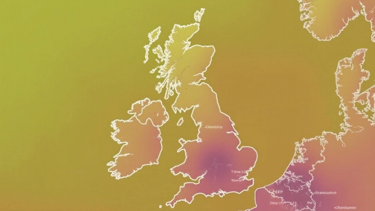
When the heat hits — and where it will be hottest
The warm-up starts fast. As the high builds, temperatures jump day by day, then peak for a run of very hot afternoons. The hottest window is most likely in the middle to late part of the week, with the south and east seeing the fiercest heat. A slight dip could follow as a weak front noses in from the Atlantic, but many places stay hot and humid until cooler air finally breaks through.
Here’s the broad picture, based on current model guidance that remains subject to small shifts:
- Early period: A quick step-up, with mid to high 20s for many, and 29–31°C in the south and Midlands.
- Peak days: 31–34°C possible in London, the Thames Valley, Home Counties, and parts of Essex, Kent, and Hertfordshire. Coastal breezes keep beaches a touch cooler.
- Elsewhere in England: 28–32°C across the Midlands and East Anglia; 27–30°C in the West Country, though sheltered inland spots could go higher.
- Wales: 26–30°C in the south and east; mid-20s further west and north.
- Scotland and Northern Ireland: Widely low to mid-20s, with 25–27°C possible in sunnier eastern Scotland and the Central Belt on the warmest day.
Nights will turn uncomfortable. Don’t be surprised by minimums holding at 18–21°C in towns and cities during the peak—close to, or even breaching, the “tropical night” mark of 20°C in the urban core. That’s what strains sleep and bumps up health risks.
Sun strength stays punchy too. UV levels in the high range during afternoon hours mean the classic hat, shade, and sunscreen mix isn’t optional—it’s basic kit this week. Light winds also raise the chance of ozone and fine particle build-up in traffic-heavy corridors, so air quality could dip at times.
Why it’s happening, risks on the ground, and how to get ready
This is a classic late-summer pattern: high pressure expands from the southwest, taps warmer air from the near Continent, and shuts the door on Atlantic fronts. With the jet stream parked to the north, weather systems that would normally cool things down get deflected. The result is a stretch of hot, dry afternoons and close, muggy nights.
When heat sticks around for several days, impacts spread beyond the thermometer. Transport operators often bring in speed restrictions on a few rail lines to reduce the risk of track buckle. Road surfaces—especially older, darker asphalt—can soften, making gritting and temporary limits more likely on busy routes. Electricity demand swings as offices and homes lean on cooling, while solar output peaks under clear skies. Farmers keep a close eye on soil moisture, heat stress in livestock, and harvest timing as afternoon temperatures spike.
Public-health teams will be watching for triggers to escalate advice. If heat continues to meet thresholds, expect a formal heat-health alert, which can prompt outreach to care homes, guidance for schools and nurseries, and reminders for outdoor workers. The pattern that brings the heat can also store up trouble for the finish: a breakdown often arrives with thunderstorms. Downpours after a hot, dry run can be intense, with local flash flooding and lightning risk. Keep an eye out for any thunderstorm warnings late in the spell.
What counts as an official heatwave? In simple terms:
- Region-specific daytime thresholds (roughly 25–28°C) must be met or exceeded.
- That needs to happen for at least three days in a row.
- Nights that stay warm add stress even if they don’t define the threshold.
How to take the edge off the heat without overthinking it:
- Hydrate early and often; avoid heavy alcohol in the hottest hours.
- Close curtains on sun-facing rooms during the day; open windows when it’s cooler outside at night.
- Check on older neighbours or relatives, and keep kids and pets out of parked cars—cracking a window isn’t enough.
- Go light on outdoor exercise in the afternoon; mornings and late evenings are kinder.
- Use high-factor sunscreen, a hat, and shade breaks; UV can bite even with haze.
- If you commute, allow extra time in case of heat-related rail or road restrictions.
Signals to watch through the week: whether nights stay stubbornly warm; any shift in wind that cools coastal areas; and the timing of that eventual breakdown front from the west. A small wobble in the high’s position can move the bullseye for the week’s top temperatures by 50 miles or more.
Bottom line: the ingredients are in place for a notably hot run, with official heatwave status likely in parts of England and a decent chance elsewhere. Plan for several days of strong heat, keep an eye on updated alerts, and treat the nights with the same respect as the afternoons. Relief will come—but probably not before the core of this hot spell has made its mark.